Agrometeorology: the risk of frost will only temporarily disappear
In the warmer-than-average weather, the vegetation is 3-4 weeks more developed than usual, but frosts can still be expected in the coming weeks, which primarily endanger the fruit crop, HungaroMet Zrt. wrote in its agrometeorological analysis on Thursday.
(Photo: Pixabay)
They wrote: the warmer and drier weather than usual continued in the past week. Average daily temperatures were between 8 and 12 degrees Celsius, which is 5-6 degrees warmer than usual at this time. Weak frosts also occurred in the frost corners. The average daily temperature of the top 5 centimeter layer of the soil was between 8 and 10 degrees. Over the past week, only a few places have had more than 5 millimeters of rain, so in most places the precipitation was less than usual in the past week as well. The ninety-day precipitation amount in the southern and eastern parts of the country is less than usual at this time. The deeper layers of the soil were saturated with moisture back in December and have maintained this state since then, and the moisture content of the middle soil layer is also adequate. However, the near-surface layer has dried up quite a bit in recent weeks in the Great Plain and Transdanubia, and the current rain may improve this.
There are still inland water spots in the Great Plain, and their extent is slowly decreasing
Even in the mild winter, the crops weakened the long-term water coverage, especially the canola, which also died in the inland water spots. Where there was no permanent inland water, the autumn crops are in good condition and have already begun to develop spectacularly. The bushy state is typical for the corn plants, and the autumn cabbage rape is starting to sprout. They drew attention to the fact that plant protection must be paid particular attention to this year, because in the winter the pathogens and pests were decimated only to a small extent by the freezing weather, mostly only at night.
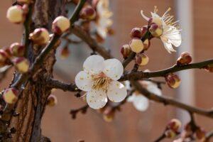
The sap circulation of the fruit trees has started, the early stone fruits are already blooming and the buds have popped on the pears, quinces, plums and cherries as well
They pointed out: however, frosts can still be expected in the coming weeks, which primarily endanger fruit production, since the fruit trees ripen in a phase of development – during flowering, the beginning of fruiting or even the development of the fruit – when they are much more sensitive to frost than in an earlier stage of development.
According to the forecast, the weather will warm up again after the temporary cooling
On Sunday, this country will be affected by a rain zone, and in total between 5 and 15 millimeters of precipitation is likely, more than this can be expected in the western part of the country. On Saturday, minus 2 or minus 3 degrees may occur in the northeast and in the frost corners, and then on Sunday it will start to warm up, and in the first days of next week, the air will warm up again above 15 degrees in a large area. In the first half of next week, it is not likely to freeze at night either, but from the middle of the week it can cool down again.
MTI
Related news
Hungarian melons can regain their lost export markets, according to producer associations
Hungarian melons can regain their export markets, a third of…
Read more >
István Nagy: the Hungarian government is not standing idly by in the drought situation
The Hungarian government is not standing idly by in the…
Read more >
OMME: Contact a specialist if you spot a swarm of bees
In the spring and summer, bee swarm sightings increase, and…
Read more >Related news
Drought, technological competition and collaboration: the domestic melon season has begun
The 2025 Hungarian melon season starts amidst serious challenges: the…
Read more >
Leadership change at Fornetti: Nándor Szabó is the new Managing Director
Nándor Szabó will take on the role of CEO of…
Read more >
Change in Zwack management: Csaba Belovai is the new CEO of Zwack Unicum Plc.
According to the decision of the owners of Zwack Unicum…
Read more >