Agrometeorology: spring sowing awaits the rain
The spring sowings are waiting for the rain, because the upper layer of the soil has already dried up in a large area and precipitation is hardly expected, at the same time, the autumn sowings are developing intensively, because there is plenty of moisture in the deeper soil layers – HungaroMet Zrt. wrote in its Thursday agrometeorological analysis.

(Photo: Pixabay)
The temperature has been 1-3 degrees Celsius higher than the long-term average in recent days. In the second half of last week, the maximums were above 15 degrees Celsius, on Saturday in the Great Plains above 20 degrees Celsius, then a cooler air mass flooded the Carpathian basin from Sunday, the peak values dropped by about 5 degrees. On the less cloudy nights, on Monday and Tuesday mornings, the air temperature cooled below freezing, especially in the east and northeast, they said.
At the end of the week, precipitation fell in many places, but a significant amount fell only in the southwest
On Thursday morning, a wave of precipitation passed through Hungary from the southwest, but this typically only brought amounts of less than 2-3 millimeters. The amount of precipitation for the last 30 days exceeds the long-term average only in the western parts, in most parts of the country it is 10-30 millimeters short of it, just as the 90-day precipitation amount is also less than the long-term average, the shortfall in the Great Plain and the southeastern part of Transdanubia is 30-60 according to the analysis, it also reaches millimeters. The layer near the surface of the soil is particularly dry in many places, but the middle soil layer is still well supplied with moisture throughout the country.
The autumn crops, where there was no permanent inundation, are in good condition, their development is two to three weeks ahead of normal
The majority of the fields of corn plants have already started to grow, and the autumn cabbage rape has green buds in many places, and in some places you can even see a few flowers. There are still inland water spots in the Great Plain, especially in the northern part, but their extent is only slowly decreasing. According to the analysis, precipitation would be needed mainly in the Great Plain, primarily for spring sowing, because the top layer of the soil is dry in many places. The larger root system of autumn crops finds plenty of moisture in the deeper layers. More and more fruit trees are blooming, and they are several weeks ahead of normal in their development During the frosty nights of the past two weeks, without frost protection, especially the early stone fruit trees suffered significant frost damage in many places. The expected warm weather during the Easter holiday will start the flowering of new fruit trees, the expected dry weather promises to be favorable for this, but the wind will hinder the work of pollinating insects.
According to HungaroMet’s information, the value of the latest vegetation index for early to mid-March, showing the “greenness” of the surface, is much higher than the long-term average across the country due to the early spring, i.e. the vegetation is more developed and more abundant than usual.
According to the forecast, we should prepare for a significant warming, the peak temperature will be between 21-27 degrees at the end of the week, and then it will decrease a few degrees from Tuesday. Frost is unlikely during the next week. Rain, showers, and thunderstorms are expected on Thursday night, mainly in the northern part of the country, followed by dry weather, but another wave of precipitation may arrive on Monday evening. In many places, the southerly wind will be brisk, strong, sometimes stormy in the northwest, and the upper half-meter layer of the soil will continue to lose its moisture content in the next week, except in the northern areas. The soil temperature will rise, up to 15 degrees by the beginning of next week, and then drop by a few degrees.
MTI
Related news
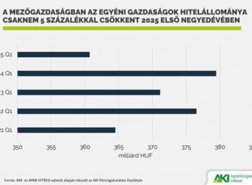
Agricultural loans decreased by 6 percent
Agricultural loans decreased by 6.0 percent to HUF 1,001.2 billion…
Read more >
Agriculture’s income-generating capacity may depend on irrigation
Europe is facing an increasingly significant water shortage, so agriculture’s…
Read more >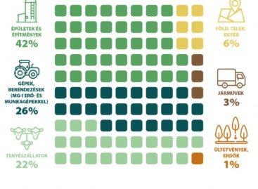
42 percent of agricultural investments were spent on buildings and structures in 2024
According to preliminary data from the Central Statistical Office, the…
Read more >Related news

Corporate leaders’ commitment to sustainability at record level
According to the latest data from the K&H Sustainability Index,…
Read more >
FAO food price index rose slightly in June due to higher prices of meat, dairy products and vegetable oils
The Food and Agriculture Organization of the United Nations (FAO)…
Read more >
What can cause the price of a wine to increase tenfold?
There are fewer of them worldwide than the number of…
Read more >