Agrometeorology: no significant frost is expected, abundant precipitation is expected

There is no need to expect significant frost damaging the orchards, and there is a prospect of abundant precipitation, the National Meteorological Service wrote in its agrometeorological analysis on Thursday.

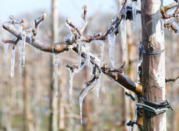
(Photo: Pixabay)
It was reported: the weather was wintry in the second half of last week, rain, sleet and snow fell in the eastern part of the country, and in the north-east by Friday morning a 5-10 centimeter layer of snow had accumulated in the area of Bodrogköz, Nyírség and Hajdúság. In most parts of the country, this much snow did not fall all winter, but the thickest snow cover of this year’s “winter” has just formed in several places in the mentioned areas, they added. The near-surface layer of the soils in the eastern and northeastern third of the country is muddy and saturated in many places, especially along the Tisza, the areas flooded by inland water are starting to grow again. The middle and deeper soil layers have a good water supply throughout the country.
The temperature for most of last week was 5-8 degrees Celsius below the long-term average
After the strong frosts in the middle of the week, between minus 4 and minus 7 degrees, the air cooled below freezing in only a few places from Friday. The temperature rose by several degrees from Sunday, and this week the maximums were already around 15 degrees.
According to the analysis, the autumn crops are in good condition
The winter wheat has started to sprout, and the canola has buds and is starting to bloom,
in some places you can even see yellowed signs. The cold weather has hindered the sowing of summer crops until now. Peaches, cherries, cherries, and plums are blooming in many places, while apples are still mostly in bud. They added: the frosts in the middle of last week without adequate protection caused damage in many places in the already blossomed and flourishing orchards. More serious spring frosts are unlikely throughout next week, there is a good chance that we are over the dangerous period – they wrote.
According to the analysis, until the middle of next week, the weather will be mainly shaped by a Mediterranean cyclone
This is already causing significant precipitation in Transdanubia, and the weather will become drier only in the second half of next week. By the middle of next week, a total of 25-40 millimeters of rain is likely in Transdanubia and 15-25 millimeters east of the Danube, so the moisture content of the soils will continue to increase. They drew attention to the fact that due to the rainy weather, the humidity will be high, the leaves of the plants will be wet for a long time, so the probability of fungal diseases also increases. At night, the temperature is typically expected to be above freezing point, at most a weak frost can occur in areas with frostbite.
MTI
Related news
Agrometeorology: Autumn sowings can develop optimally, but frost threatens fruit trees
🎧 Hallgasd a cikket: Lejátszás Szünet Folytatás Leállítás Nyelv: Auto…
Read more >
Agrometeorology: the soil needs precipitation, but dry weather is ideal for flowering fruit trees
🎧 Hallgasd a cikket: Lejátszás Szünet Folytatás Leállítás Nyelv: Auto…
Read more >
Agrometeorology: autumn sowings overwintered well, even managed to strengthen at the beginning of winter
🎧 Hallgasd a cikket: Lejátszás Szünet Folytatás Leállítás Nyelv: Auto…
Read more >Related news

Aldi, Auchan, Lidl, PENNY, SPAR, Tesco: in 2024 they paid more than 710 billion into the budget, while closing with a loss
🎧 Hallgasd a cikket: Lejátszás Szünet Folytatás Leállítás Nyelv: Auto…
Read more >
OKSZ: Household consumption cannot keep up with the growth rate of real wages
🎧 Hallgasd a cikket: Lejátszás Szünet Folytatás Leállítás Nyelv: Auto…
Read more >
KSH: retail turnover in February exceeded the same period of the previous year by 3.8 percent and the previous month by 0.4 percent
🎧 Hallgasd a cikket: Lejátszás Szünet Folytatás Leállítás Nyelv: Auto…
Read more >