Agrometeorology: precipitation is good for autumn sowing

This week, heavy rain fell nationwide, with the exception of the Lesser Plain, which was much needed by the late-sown winter wheat, but the cool weather continues to hinder its development and strengthening – wrote HungaroMet Zrt. in its agrometeorological analysis on Thursday.
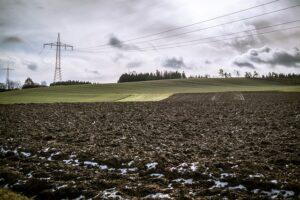
(Photo: Pixabay)
They wrote: on Monday, 1-3 millimeters of rain fell in several places in the northern regions, then on Tuesday, 1-6 millimeters in a larger area, in the eastern and northeastern parts of the country. At dawn on Wednesday, a cold front brought nationwide precipitation, with amounts between 5-25 millimeters falling in most parts of the country, with less rain falling only in the north and northwest. The near-surface soil layer, which had dried out considerably by mid-November, has now been thoroughly moistened, with the exception of the Lesser Plain, and moisture has also reached the middle layer, mainly in the south and southwest. The temperature has varied within quite wide limits over the past week, but overall it has been 2-5 degrees Celsius colder than the long-term average: on gloomy, humid, foggy days and areas, only values between 2-4 degrees were measured during the day, while in sunnier areas the air warmed up to around 10 degrees. At night, the air cooled to between minus 2 and minus 5 degrees in clear places.
According to the analysis, the rapeseed is very developed and in good condition thanks to the rainy but relatively mild weather typical of the first half of autumn
However, due to the dry weather from mid-October to mid-November, the upper layer of the soil affected by the root system of the winter cereals has dried out significantly. The cereals sown in early October found enough moisture for optimal early development, these stands are typically in a 3-5 leaf state or are already bushy, but during the later sowings the soil dried out and they emerged with difficulty and unevenly, they are behind in development, and the cooler than average November does not help them to strengthen either.
According to the forecast, another precipitation zone will arrive from the west on Thursday night
From this, snowfall can be expected in the northern half of the country, sleet and rain in the south, a total amount of between 5-20 millimeters is likely, with the least expected in the northwest again this time. The landscape will turn white in the northern and northeastern parts of the country, especially in the Northern Central Mountains region, the snow layer may remain for several days. The temperature will rise from values between minus 2 and plus 3 degrees at night to only between 1-6 degrees during the day. Drier and warmer days will follow from Saturday, and then mostly cloudy weather is expected across the country from Tuesday, with scattered rain and then sleet.
MTI
Related news

Agrometeorology: the soil needs precipitation, but dry weather is ideal for flowering fruit trees
🎧 Hallgasd a cikket: Lejátszás Szünet Folytatás Leállítás Nyelv: Auto…
Read more >
Agrometeorology: autumn sowings overwintered well, even managed to strengthen at the beginning of winter
🎧 Hallgasd a cikket: Lejátszás Szünet Folytatás Leállítás Nyelv: Auto…
Read more >
Agrometeorology: autumn sowing is in great need of precipitation
🎧 Hallgasd a cikket: Lejátszás Szünet Folytatás Leállítás Nyelv: Auto…
Read more >Related news

Oat-based “feta” wins the cheese innovation competition of Lidl Germany and ProVeg
🎧 Hallgasd a cikket: Lejátszás Szünet Folytatás Leállítás Nyelv: Auto…
Read more >
Finger Food Experience
🎧 Hallgasd a cikket: Lejátszás Szünet Folytatás Leállítás Nyelv: Auto…
Read more >
KPMG: Easter boom: the season is exploding for families, retail and the chocolate industry
🎧 Hallgasd a cikket: Lejátszás Szünet Folytatás Leállítás Nyelv: Auto…
Read more >