Agrometeorology: the autumn-winter recharge of the soils has begun

In the past week, the weather turned wetter, and in the next few days, a significant amount of rain may fall across the country, the National Meteorological Service wrote in its agrometeorological analysis on Thursday.
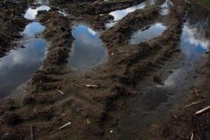
(Photo: Pixabay)
They wrote: in the past week, several weather fronts passed over the country, which brought heat and significant precipitation in several places. In a significant part of Transdanubia and in the northern regions, the soil layer near the surface became thoroughly wetted, became muddy in many places, and the moisture also reached the middle, 20-50 centimeter layer. In the Great Plain, however, all layers of the soil are extremely dry for the time being, and the top one meter lacks more than 150 millimeters of saturation. The amount of precipitation for the past thirty days shows a considerable deficit of 15-40 millimeters in most parts of the country.
The temperature was 5-8 degrees Celsius warmer than usual during the past week, daily averages were between 18-23 degrees
At dawn on Saturday and Sunday, the air did not cool below 15-20 degrees, and on Friday it was 25-29 degrees during the day. They added: the corn harvest has not yet ended, and the rainy weather of the past week in many places has hampered the work, as has the harvesting of apples, pears, and plums. The harvest has already finished in most places, there are fewer and fewer grapes still outside, the sunny, warm weather would also increase the sugar level.
However, autumn crops need rain very much
Rapeseed is well developed, mostly with 6-8 leaves. In addition to the heat, the current rainfall is good for the sowing of wheat, which is still in progress, as well as for germination and germination. 5-7-leaf stands are typical for barley, and wheat is in the state of germination, but in more and more places you can see stands with 1-2 leaves as well.
The weather will continue to be milder than usual, but more rainy
On Friday, the rain will fall in more and more directions, and then during the day a showery zone will pass, in which there may even be thunderstorms, 20-40 millimeters of precipitation is expected in the northern half of the country, and 5-20 millimeters in the south. After that, drier weather is likely, but there may be rain in several places again on Tuesday, but no more than 5 millimeters of rain is expected. The temperature does not change significantly, the maximum values will be below 15 degrees on gloomy, persistently rainy days and landscapes, otherwise the air will warm up to 18-23 degrees during the day, and the minimum values are mostly expected between 5 and 10 degrees, and the weather will often be windy. – they wrote.
MTI

Related news

Agrometeorology: autumn sowing is in great need of precipitation
🎧 Hallgasd a cikket: Lejátszás Szünet Folytatás Leállítás Nyelv: Auto…
Read more >
Agrometeorology: the soil is drying out
🎧 Hallgasd a cikket: Lejátszás Szünet Folytatás Leállítás Nyelv: Auto…
Read more >
Agrometeorology: the soil near the surface dries out a lot in sunny, dry weather
🎧 Hallgasd a cikket: Lejátszás Szünet Folytatás Leállítás Nyelv: Auto…
Read more >Related news

Green transition on the air conditioning market
🎧 Hallgasd a cikket: Lejátszás Szünet Folytatás Leállítás Nyelv: Auto…
Read more >
BudapestGO continues to develop: the March application update brings more convenient use
🎧 Hallgasd a cikket: Lejátszás Szünet Folytatás Leállítás Nyelv: Auto…
Read more >
Why does the rabbit lay eggs at Easter?
🎧 Hallgasd a cikket: Lejátszás Szünet Folytatás Leállítás Nyelv: Auto…
Read more >