Agrometeorology: autumn sowing is in great need of precipitation

Autumn sowing started to develop earlier than usual, but it would be in great need of precipitation, because it has not rained for three weeks – wrote HungaroMet Zrt. in its agrometeorological analysis on Thursday.
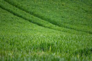
According to the analysis, in the past week, only a few showers with minimal precipitation occurred in some places, the last precipitation affecting a larger area fell three weeks ago. The precipitation total of the past thirty days is 5-30 millimeters below the multi-year average, and in the ninety-day precipitation total, only the southern part of the country has a surplus, with 20-50 millimeters less than usual at this time of year in most parts of the country. The part near the surface of the soil has dried out a lot in recent weeks. In most parts of the Great Plain and the Mezőföld, the upper one-meter layer of the soil did not fill with moisture during the winter. The average temperature has been 3-5 degrees Celsius higher than the long-term average for weeks. Light frosts occurred at night, and the maximum temperature was between 15 and 20 degrees.
Rapeseed and winter cereals have started to develop, their green mass is increasing
During the sunny, dry weather that has characterized the past few weeks, the surface layer of the soil has dried out, but the plants can still find plenty of moisture in the deeper layers, but for ideal development, abundant rainfall would be needed. Early stone fruits are blooming in the southern areas, apricots are just starting to bloom in the north, but most fruit tree buds have already burst. The harvest will be threatened by light frosts expected in the coming days. Apricots are already damaged in the flowering development phase by frosts stronger than minus 2 or minus 3 degrees Celsius in the evening. Peaches are also damaged at similar temperatures, but they are not yet in bloom, so they are less at risk. The latest vegetation index value for the end of February and beginning of March, which shows the “greenness” of the surface, is already increasing due to the early arrival of spring, the map has started to grow earlier than usual, therefore showing much more developed vegetation. According to the forecast, the weather will turn slightly cooler, the peak temperature is likely to be around 15 degrees, and light frosts may occur at night. Frosts of more than minus 2 degrees, which are damaging to fruit trees, are likely to develop only in frost-prone areas. There is no prospect of significant precipitation until the middle of next week, but light rain and showers may occur on several days, so the soils will continue to dry out.
MTI
Related news
The processing sales price of chicken legs has decreased
🎧 Hallgasd a cikket: Lejátszás Szünet Folytatás Leállítás Nyelv: Auto…
Read more >
The producer price of slaughter cows increased by 30 percent
🎧 Hallgasd a cikket: Lejátszás Szünet Folytatás Leállítás Nyelv: Auto…
Read more >
István Nagy: The horticulture of the future is being built in Szentes
🎧 Hallgasd a cikket: Lejátszás Szünet Folytatás Leállítás Nyelv: Auto…
Read more >Related news

Aldi, Auchan, Lidl, PENNY, SPAR, Tesco: in 2024 they paid more than 710 billion into the budget, while closing with a loss
🎧 Hallgasd a cikket: Lejátszás Szünet Folytatás Leállítás Nyelv: Auto…
Read more >
OKSZ: Household consumption cannot keep up with the growth rate of real wages
🎧 Hallgasd a cikket: Lejátszás Szünet Folytatás Leállítás Nyelv: Auto…
Read more >
KSH: retail turnover in February exceeded the same period of the previous year by 3.8 percent and the previous month by 0.4 percent
🎧 Hallgasd a cikket: Lejátszás Szünet Folytatás Leállítás Nyelv: Auto…
Read more >