Agrometeorology: autumn sowing needs more and more precipitation
Autumn sowing would need more and more precipitation, and even though moist air will flow into the Carpathian basin in the coming days, the distribution of precipitation will not be uniform, some parts of the country may even miss out on heavy rain, the National Meteorological Service wrote in its agrometeorological analysis on Thursday.

(Photo: Pixabay)
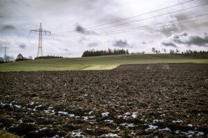
It was recalled: on Sunday, a cold front caused rain in many places, but a larger amount of more than 5 millimeters fell only in the northeast and west. The precipitation amount of the last 30 days usually shows a deficit of 10-30 millimeters compared to the long-term average. The top 20 cm layer of the soil has dried up a lot since the last rain at the end of September, and the deeper soil layers dried up in a large area at the beginning of autumn, and since then the moisture has only been running out. The peak temperature last week on Thursday, Friday and Saturday was typically around 25 degrees Celsius, which is much higher than usual at this time, then a cold front arrived on Sunday and from then on the air only warmed up to 15 degrees in the afternoon. After the cold air calmed down and the cloudiness decreased, it was frosty in many places on Tuesday and Wednesday, with minus 3 and minus 5 degrees in some places at a height of 2 meters.
They added: the corn harvest is in full swing, and dry weather is favorable for achieving optimal grain moisture, as well as for harvesting fruits. In Szabolcs, for example, there are still many apples and even plums on the trees. The rain at the end of September was favorable for autumn cabbage rape, but since then little rain has fallen only in the north, and the soil has dried up a lot in most parts of the country. The later-sown stands still mostly have 4-6 leaves, while the earlier ones already have 6-8 leaves, and they are all waiting for a heavy rainfall. Seedbed preparation and sowing of winter wheat is underway, but the upper part of the soil is too dry for germination.
In the continuation, changeable, mild, often rainy weather is to be expected, more or less rain will arrive several times, most predictably on Saturday and Wednesday. All in all, 10-20 millimeters of precipitation may fall in many places until the middle of next week, but its spatial distribution will probably not be uniform, some parts of the country may even be spared from the heavy rain, but the layer near the surface of the soil will get wet, which will affect the developing rapeseed and autumn barley, as well as the sown wheat will prosper. The temperature will continue to rise, and then the warming will moderate slightly from Sunday, but maximums of around 23-25 degrees are still expected in the south, and around 15 degrees in the north. Nocturnal frost is unlikely until the middle of next week.
MTI
Related news
Agrometeorology: Autumn sowings can develop optimally, but frost threatens fruit trees
🎧 Hallgasd a cikket: Lejátszás Szünet Folytatás Leállítás Nyelv: Auto…
Read more >Agrometeorology: the soil needs precipitation, but dry weather is ideal for flowering fruit trees
🎧 Hallgasd a cikket: Lejátszás Szünet Folytatás Leállítás Nyelv: Auto…
Read more >Agrometeorology: autumn sowings overwintered well, even managed to strengthen at the beginning of winter
🎧 Hallgasd a cikket: Lejátszás Szünet Folytatás Leállítás Nyelv: Auto…
Read more >Related news
Oat-based “feta” wins the cheese innovation competition of Lidl Germany and ProVeg
🎧 Hallgasd a cikket: Lejátszás Szünet Folytatás Leállítás Nyelv: Auto…
Read more >The horticulture of the future is being built in Szentes
🎧 Hallgasd a cikket: Lejátszás Szünet Folytatás Leállítás Nyelv: Auto…
Read more >Finger Food Experience
🎧 Hallgasd a cikket: Lejátszás Szünet Folytatás Leállítás Nyelv: Auto…
Read more >


