Arctic cold is coming, blooming fruit trees must be protected from frost

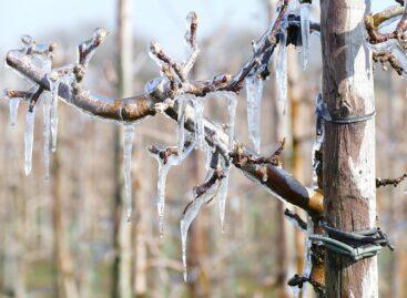
Air of arctic origin will flood the Carpathian basin at the beginning of next week, and the blooming fruit trees must be protected from night frosts from Tuesday, the National Meteorological Service wrote in this week’s agrometeorological analysis on Thursday.
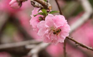
(Photo: Pixabay)
In the analysis published on the website, they wrote: the mostly dry but increasingly warm weather of the past week favored spring work and the rapid development of vegetation. At the same time, the layer of the soil close to the surface has dried up a lot since the rains in the middle of last week, while the upper 20 centimeter layer to the northwest of Rába is already critically dry. The medium and deeper soil layers mostly have a good water supply, in the eastern and southern regions of the Great Plain, inland water still occurs in spots. From the beginning of the week, the frosts stopped, and the air warmed up to 15-20 degrees Celsius during the day. The 5-centimeter soil temperature is now between 9 and 12 degrees, and although it currently exceeds 10 degrees in a large area, this cannot yet be considered permanent.
The autumn crops are typically in good condition, their spring development has started
The winter wheat is bushing nicely and the canola is also looking good. More and more fruit varieties are blooming or are in the immediate pre-blooming state: in addition to almonds and apricots, peaches have already blossomed, and the flower buds of apples and pears are also strongly swollen. They added: the subsequent cooling in two waves will set back the premature development of vegetation, and precipitation will also arrive. Behind the cold front arriving on Sunday evening, cold arctic air will flood the Carpathian Basin on Monday and Tuesday, accompanied by strong, gale-force winds in many directions. Another 10 millimeters of rain is expected from Sunday evening to Monday evening, and on Tuesday and Wednesday snow, sleet, and showers are possible. At the beginning of the week, temperatures below 10 degrees will be typical during the day, and on Tuesday and Wednesday at dawn the air will cool below freezing in large areas.
MTI
Related news
Agrometeorology: Autumn sowings can develop optimally, but frost threatens fruit trees
🎧 Hallgasd a cikket: Lejátszás Szünet Folytatás Leállítás Nyelv: Auto…
Read more >
Agrometeorology: the soil needs precipitation, but dry weather is ideal for flowering fruit trees
🎧 Hallgasd a cikket: Lejátszás Szünet Folytatás Leállítás Nyelv: Auto…
Read more >
Agrometeorology: autumn sowings overwintered well, even managed to strengthen at the beginning of winter
🎧 Hallgasd a cikket: Lejátszás Szünet Folytatás Leállítás Nyelv: Auto…
Read more >Related news

Aldi, Auchan, Lidl, PENNY, SPAR, Tesco: in 2024 they paid more than 710 billion into the budget, while closing with a loss
🎧 Hallgasd a cikket: Lejátszás Szünet Folytatás Leállítás Nyelv: Auto…
Read more >
OKSZ: Household consumption cannot keep up with the growth rate of real wages
🎧 Hallgasd a cikket: Lejátszás Szünet Folytatás Leállítás Nyelv: Auto…
Read more >
KSH: retail turnover in February exceeded the same period of the previous year by 3.8 percent and the previous month by 0.4 percent
🎧 Hallgasd a cikket: Lejátszás Szünet Folytatás Leállítás Nyelv: Auto…
Read more >