Agrometeorology: hard frosts and heavy rainfall were much needed

The past week brought hard night frosts and the very end of winter brought heavy rainfall; both were much needed from an agricultural perspective – wrote HungaroMet Zrt. in its agrometeorological analysis on Thursday.

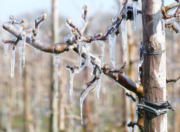
(Photo: Pixabay)
They wrote that at the beginning of the week, scattered precipitation formed in the western part of the country, and then on Wednesday a few millimeters fell in the central part of the country. The more serious precipitation arrived first in Transdanubia on Thursday, where 5-20 millimeters of rain fell until noon. The rain is much needed, as the total precipitation of the past 30 and 90 days is also well below the long-term average. The soil has not yet been replenished at a depth of about one meter, especially in the Great Plain, and the upper one-meter soil layer was 20-80 millimeters short of saturation by Wednesday. Last week, from Wednesday to Sunday, temperatures dropped to around minus 10 degrees Celsius at night in a large area, causing the ground to freeze to a depth of about 5-20 centimeters. Deeper ground frosts developed in the northeast, but have mostly cleared up since the end of the week.
Rapeseed is well-developed and in good condition thanks to the rainy but relatively mild weather typical of the first half of autumn
In the case of cereals sown in October, the dry period resulted in uneven germination and difficult early development in many places, primarily in the southern parts of the Great Plain. In the northwestern part of the country, signs of drought have already begun to appear in terms of autumn sowing due to the very dry topsoil in recent weeks, but Thursday’s rainfall will help a lot in this regard. Mild spring weather in January repeatedly disrupted the deep dormancy phase of vegetation, and the persistent cold that arrived in February was much needed to curb the prematurely initiated development. Frosts of around minus 10 degrees, which are necessary for the thinning of pests and pathogens, also occurred in several places in the past week.
According to the forecast, rainy weather is expected at first, with precipitation spreading to the central and eastern areas, with a total of 5-25 millimeters of rain expected
This amount will replace the moisture in the upper soil layer that has dried out in recent weeks in most parts of the country, which is urgently needed in the northwestern areas, but this rain will not really reach the deeper layers of the unreinforced soil of the Great Plain. From Saturday, a mostly dry period will begin again and there will be more and more sunshine, but mostly light night frosts will return next week, and during the day the warming will increase day by day, with temperatures still around 10 degrees at the end of the week and around 15 degrees in the middle of next week.
MTI
Related news
Agrometeorology: Autumn sowings can develop optimally, but frost threatens fruit trees
🎧 Hallgasd a cikket: Lejátszás Szünet Folytatás Leállítás Nyelv: Auto…
Read more >
Agrometeorology: the soil needs precipitation, but dry weather is ideal for flowering fruit trees
🎧 Hallgasd a cikket: Lejátszás Szünet Folytatás Leállítás Nyelv: Auto…
Read more >
Agrometeorology: autumn sowings overwintered well, even managed to strengthen at the beginning of winter
🎧 Hallgasd a cikket: Lejátszás Szünet Folytatás Leállítás Nyelv: Auto…
Read more >Related news

Hungarian consumers are saving on ham, label reading is becoming more important
🎧 Hallgasd a cikket: Lejátszás Szünet Folytatás Leállítás Nyelv: Auto…
Read more >
International food prices have risen due to the impact of the Middle East conflict on energy prices
🎧 Hallgasd a cikket: Lejátszás Szünet Folytatás Leállítás Nyelv: Auto…
Read more >
It doesn’t matter how big the egg is on the shelves: genetics, age, and the chains’ tender logic decide
🎧 Hallgasd a cikket: Lejátszás Szünet Folytatás Leállítás Nyelv: Auto…
Read more >