Agrometeorology: in the central and southeastern parts of the country, summer crops would benefit from rainfall

There is already a drought in the central and southeastern parts of the country, the summer field crops in these areas can only get moisture from the deeper soil layers, the National Meteorological Service wrote in its agrometeorological analysis on Thursday.
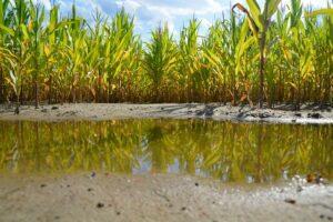
(Photo: Pixabay)
They wrote that there have been showers and thunderstorms several times in the past few days, and damaging windstorms have also formed in some places. In the last 10 days, 20-40 millimeters of rain fell in a large area, in the southern and southwestern regions of Transdanubia and in many places in the northeast, much more than this fell, however, in the central regions of the Great Plain, it did not even reach 10 millimeters in some places. The amount of precipitation for the past 30 days already shows a significant deficit compared to the long-term average in most parts of the country. The moisture content of the soils increased a lot, the upper 20 centimeter layer was well moistened, except for the central and southeastern parts of the country. Drought is in the Budapest – Dunaújváros – Kecskemét – Szolnok – Jászberény and Bácsalmás – Szeged – Mezőkovácsháza areas, the summer field crops in these areas can only get moisture from the deeper soil layers, where the water content is still satisfactory throughout the country – they added.
The harvesting of the ears and rapeseed has already been completed in most places, and the wheat harvest is also coming to an end
Maize is well developed in most places, in the Miskolc region 3-meter stand height and double ears are not uncommon either. The corn is in the stage of ear development, and the sunflower is nearing the end of flowering. The rainfall of the past few days was extremely important for these cultures as well, but especially in the Great Plain, more rainfall would be needed for their optimal development, for now they still find some moisture in the deeper soil layer. Changeable weather is expected in the coming days, a marked frontal system will arrive on Sunday and Tuesday-Wednesday next week, with which more or less precipitation can be expected, with high regional variability. Warming is expected by the end of the week, followed by a few degrees of cooling by Monday.
MTI
Related news

Agrometeorology: the soil needs precipitation, but dry weather is ideal for flowering fruit trees
🎧 Hallgasd a cikket: Lejátszás Szünet Folytatás Leállítás Nyelv: Auto…
Read more >
Agrometeorology: autumn sowings overwintered well, even managed to strengthen at the beginning of winter
🎧 Hallgasd a cikket: Lejátszás Szünet Folytatás Leállítás Nyelv: Auto…
Read more >
Agrometeorology: autumn sowing is in great need of precipitation
🎧 Hallgasd a cikket: Lejátszás Szünet Folytatás Leállítás Nyelv: Auto…
Read more >Related news

Oat-based “feta” wins the cheese innovation competition of Lidl Germany and ProVeg
🎧 Hallgasd a cikket: Lejátszás Szünet Folytatás Leállítás Nyelv: Auto…
Read more >
Finger Food Experience
🎧 Hallgasd a cikket: Lejátszás Szünet Folytatás Leállítás Nyelv: Auto…
Read more >
KPMG: Easter boom: the season is exploding for families, retail and the chocolate industry
🎧 Hallgasd a cikket: Lejátszás Szünet Folytatás Leállítás Nyelv: Auto…
Read more >